We have written previously about mobiles as sensing devices to collect data and develop maps and understand patterns of human movement, traffic, air pollution, and even the spread of diseases. The mass-tracking of mobile devices and the use of mobiles as ubiqitous sensing devices are very promising but also have generated controversy, most recently when a Boston University study published in Nature revealed it has tracked 100,000 anonymized mobile phone users' position in an unidentified country (we suspect the UK) without these users' consent.
The study, though objectionable in its methods, revealed nonetheless interesting travel patterns of the individuals tracked. The authors note that "after correcting for differences in travel distances and the inherent anisotropy of each trajectory, the individual travel patterns collapse into a single spatial probability distribution, indicating that, despite the diversity of their travel history, humans follow simple reproducible patterns. This inherent similarity in travel patterns could impact all phenomena driven by human mobility, from epidemic prevention to emergency response, urban planning and agent-based modelling."
We stongly believe in a participatory approach that involves individials in this kind of data collection, in the form of a 'participatory urbanism' that involved participants in mass-scale mobile sensing.
The credo of mobile technology in the context of environmental citizen participation is described as:
"..the open authoring, sharing, and remixing of new or existing urban technologies marked by, requiring, or involving participation, especially affording the opportunity for individual citizen participation, sharing, and voice. Participatory Urbanism builds upon a large body of related projects where citizens act as agents of change. There is a long history of such movements from grassroot neighborhood watch campaigns to political revolutions. It is not a disconnected personal phone application, a domestic networked appliance, a mobile route planning application, an office scheduling tool, or a social networking service. Participatory Urbanism promotes new styles and methods for individual citizens to become proactive in their involvement with their city, neighborhood, and urban self..."
A leader in this field is the University of California Los Angeles CENS Lab. It has a number of projects that utlize mobile devices as mobile sensing devices.
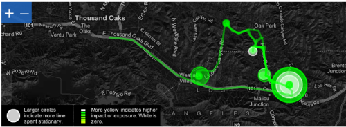
- CycleSense. Bikers carry a GPS logger or a mobile phone equipped with GPS technology during their commute. These tools automatically upload their routes to a secure website. Participants can log in to their private website to see their route combined with existing data, including air quality, time-sensitive traffic conditions, and aggregate traffic accidents along the route. Participants can obtain suggestions to improve their routes based on individual preferences (e.g. to reduce exposure to air pollution). Bikers can document hazards and impediments along their way by taking photos with a mobile phone or sending a text message to CENS servers. This information will help CENS improve its maps and models so that all bikers in the region will benefit from these bike-centric updates.
- Project Surya. In the next two years, Project Surya will replace traditional bio-fuel based cooking methods with inexpensive solar and other energy-efficient cookers in 6,000 homes in rural India. Scientists will place simple filter-based instruments in each household to record aggregate soot levels and document the cooker's ability to reduce indoor air pollution.
In the past, air pollution studies have had to balance the trade-off of cost with reliability during data collection. Utilizing prohibitively expensive instruments limited the number of sites that could be monitored. On the other hand, cheaper instruments suffered from questionable accuracy and the inability to transmit data in real-time, a feature which allows for adjustment of data collection during field deployments. Cell phones will make it easy to collect high quality data from each filter in real-time. Participants will capture and transmit images of the air filters to a centralized location for analysis. This approach has several advantages. First, soot readings will be obtained using image analysis techniques to extract filter color. This automated approach contrasts with the current method of relying upon highly subjective visual estimates of filter color provided by individuals. Second, time and location stamping of readings, provided by cell phones, will reduce accounting errors introduced through manual data entry. Third, automated integrity checks that ensure image capture and that confirm daily filter replacement, will lead to improved data quality.
 The just-released PEIR Health Campaign. In order to document a person's exposure, the PEIR Health Campaign uses locations of polluting sources recorded by individuals in conjunction with models derived from data gathered and maintained by government agencies and other scientific organizations. Today's mobile phones cannot directly measure carbon dioxide or particulate matter. PEIR, the Personal Environmental Impact Report, uses GPS technology to determine the values indirectly. As you go about your routine -- jogging, commuting, running errands-- your mobile phone uses GPS and cell towers to record and upload your location every few seconds to your secure profile. Based on this location trace, the system infers your activity (walking, biking, driving, riding the bus) and logs it throughout the day. PEIR maps this combination of location, time, and activity to regional air quality and weather data to calculate your personal carbon footprint and your exposure to fine particles (PM 2.5) in the air.
People can also use the cameras and microphones available on their cell phones to document polluting sources. Phones can automatically record where and when pictures and audio recordings were taken. Users can stamp the data with relevant keywords. The 'geotagged' data are automatically uploaded to web servers where they are cataloged and analyzed. Local visibility indices may be extracted from panoramic images of the landscape, and noise pollution inferred from audio recordings outside a house.
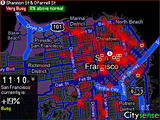 A commercial (and so far somewhat frivulous) application is CitySense, an innovative mobile application for local nightlife discovery and social navigation. The application on the mobile answers the question, "Where is everybody?" Citysense shows, in the form of a heat map, the overall activity level of the city, top activity hotspots, and places with unexpectedly high activity, all in real-time by tracking taxi driver movements. Then it links to Yelp and Google to show what venues are operating at those locations.
We can imagine the same technology for a number of social applications such as tracking traffic patterns and urban movements, refugee and migrant tracking, etc.
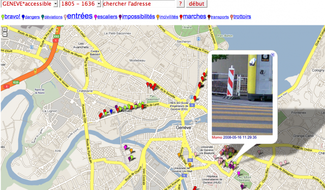 Lastly, an interesting collective in Europe, Xexe, is developing participatory maps such as this one of inaccessible Geneva. People with disabilities used GPS-equipped mobile phones to photograph every obstacle they came across in Geneva. The pictures are uploaded via MMS to a map on the Web.
This is an exploding and very interesting field that we are tracking closely as it has such cross- and multi-disciplinary applications in humanitarian relief, environmental data tracking, urban planning, public health, and many others.
For an introductory video on the principles and ideas behind participatory urbanism, see the overview from CENS.


Post new comment