(This piece was originally written by The World Bank; it is republished here with permission)
Following Liberia’s 14-year civil war, infrastructure and service provision was virtually non-existent. The water sector’s initial response to the emerging humanitarian crisis, providing potable water for the short term, was effective as a triage measure. From a long-term perspective, it was ad-hoc, uncoordinated and not comprehensive.
Basic data regarding the overall health of the water system was wiped out by the war and surviving information was outdated. Ad-hoc crisis management helped solve an immediate humanitarian crisis; however the government then needed to shift to long-term planning and investment to address the chronic shortage of potable water points for citizens. The WHO describes these as “water point(s) that, by nature of [their] construction or through active intervention, [are] protected from outside contamination, in particular from contamination with fecal matter.”
As of 2005, only 51% of the population had access to safe drinking water. In order to effectively allocate assets towards this end, there first needed to be a clear picture of the locations of functioning vs. non-functioning water points.
The World Bank, in partnership with other local and multinational organizations, created a baseline map of existing improved water points as the first step of this long-horizon process.
The Innovation
Similar to other data collection projects, paper-based forms become bulky, possibly illegible, and misplaced or damaged. To address these concerns, the project team used FLOW (Field Level Operations Watch), an Android-based mobile application that is capable of geo-tagging water points as well as pertinent data.
FLOW has three basic functionalities: data collection, data analysis, and visualization.
- Data Collection: An Android phone replaces paper questionnaires. Field enumerators enter the data on each water point directly into the phone, which can also be used to add the GPS coordinates and a picture of the water point. A team can write its own questionnaire and upload it, or select from a number of standard water point questionnaires that come with the application. Thus one cell phone per enumerator replaces the need for a GSP device, camera, and multiple paper copies of the questionnaire. If there is cell phone network coverage, the enumerators can immediately transmit the survey data to the database on the online server. If not, the data remain on the phone’s SIM card for later uploading directly onto a computer with Internet access.
- Data Analysis and the Cloud: Data are stored in an online database, although of course they can be downloaded as needed. Authorized users can access the database via the Internet. FLOW can perform statistical analysis, and generate charts and graphs.
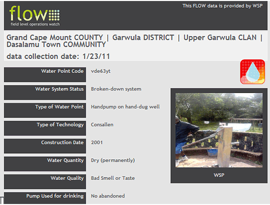
- Data Visualization: Figure 1 shows a map of water points produced by FLOW. Figure 2 shows the data that may be displayed by clicking on an individual water point on the map. These examples illustrate only some of the visualization capabilities of FLOW.
Data Visualization: Figure 1 shows a map of water points produced by FLOW.
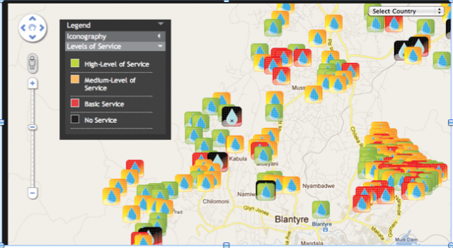
Figure 2 shows the data that may be displayed by clicking on an individual water point on the map.
Replicability and Sustainability
Cost: The exercise cost about US$300,000. Most of the budget was for staff, but it also included the costs of the phones, fuel and repair for the motorbikes, and a fee of $10,000 to Gallatin Systems, the developer of FLOW, to provide back up and adapt FLOW to the requirements of the project.
User requirements: Basic knowledge of the Android operating platform and functionality is required. This includes taking a picture, keying in text and uploading data. Training time would be minimal in other projects. Trainings regarding the water points themselves takes longer than that of the technology.
Limitations: The Liberia experience uncovered some practical limitations in using FLOW. For example, the battery life in the phones was limited, while access to electricity for charging was unreliable. This was addressed through external chargers powered by standard AA-batteries. As there was no cell phone or Internet connection in the field, enumerators came into the administrative headquarters and downloaded the data onto computers, from where the data were transmitted to the online server.
(For more information on the FLOW project, check out this MobileActive.org case study on the program. For a look at a different water monitoring project, read about the Maji Matone project in Tanzania.)
FLOW: The World Bank and Water Point Mapping in Liberia Locations
(This piece was originally written by The World Bank; it is republished here with permission)
Following Liberia’s 14-year civil war, infrastructure and service provision was virtually non-existent. The water sector’s initial response to the emerging humanitarian crisis, providing potable water for the short term, was effective as a triage measure. From a long-term perspective, it was ad-hoc, uncoordinated and not comprehensive.
Basic data regarding the overall health of the water system was wiped out by the war and surviving information was outdated. Ad-hoc crisis management helped solve an immediate humanitarian crisis; however the government then needed to shift to long-term planning and investment to address the chronic shortage of potable water points for citizens. The WHO describes these as “water point(s) that, by nature of [their] construction or through active intervention, [are] protected from outside contamination, in particular from contamination with fecal matter.”
As of 2005, only 51% of the population had access to safe drinking water. In order to effectively allocate assets towards this end, there first needed to be a clear picture of the locations of functioning vs. non-functioning water points.
The World Bank, in partnership with other local and multinational organizations, created a baseline map of existing improved water points as the first step of this long-horizon process.
The Innovation
Similar to other data collection projects, paper-based forms become bulky, possibly illegible, and misplaced or damaged. To address these concerns, the project team used FLOW (Field Level Operations Watch), an Android-based mobile application that is capable of geo-tagging water points as well as pertinent data.
FLOW has three basic functionalities: data collection, data analysis, and visualization.
- Data Collection: An Android phone replaces paper questionnaires. Field enumerators enter the data on each water point directly into the phone, which can also be used to add the GPS coordinates and a picture of the water point. A team can write its own questionnaire and upload it, or select from a number of standard water point questionnaires that come with the application. Thus one cell phone per enumerator replaces the need for a GSP device, camera, and multiple paper copies of the questionnaire. If there is cell phone network coverage, the enumerators can immediately transmit the survey data to the database on the online server. If not, the data remain on the phone’s SIM card for later uploading directly onto a computer with Internet access.
- Data Analysis and the Cloud: Data are stored in an online database, although of course they can be downloaded as needed. Authorized users can access the database via the Internet. FLOW can perform statistical analysis, and generate charts and graphs.
- Data Visualization: Figure 1 shows a map of water points produced by FLOW. Figure 2 shows the data that may be displayed by clicking on an individual water point on the map. These examples illustrate only some of the visualization capabilities of FLOW.
Data Visualization: Figure 1 shows a map of water points produced by FLOW.
Figure 2 shows the data that may be displayed by clicking on an individual water point on the map.
Replicability and Sustainability
Cost: The exercise cost about US$300,000. Most of the budget was for staff, but it also included the costs of the phones, fuel and repair for the motorbikes, and a fee of $10,000 to Gallatin Systems, the developer of FLOW, to provide back up and adapt FLOW to the requirements of the project.
User requirements: Basic knowledge of the Android operating platform and functionality is required. This includes taking a picture, keying in text and uploading data. Training time would be minimal in other projects. Trainings regarding the water points themselves takes longer than that of the technology.
Limitations: The Liberia experience uncovered some practical limitations in using FLOW. For example, the battery life in the phones was limited, while access to electricity for charging was unreliable. This was addressed through external chargers powered by standard AA-batteries. As there was no cell phone or Internet connection in the field, enumerators came into the administrative headquarters and downloaded the data onto computers, from where the data were transmitted to the online server.
(For more information on the FLOW project, check out this MobileActive.org case study on the program. For a look at a different water monitoring project, read about the Maji Matone project in Tanzania.)

Post new comment