If 2009 is the year of the mobile phone for social impact, then Earth Day should mark a special occasion in this regard. More and more organizations and people are discovering how mobile phones can be used for social impact, including how to use mobile tech for environmental protection, sensing, and to leverage just-in-time information to make our movements and actions more environmentally friendly.
An emerging field of research, for example, uses mobiles for "urban sensing," allowing phones to collect scientific data in new and innovative ways. By affixing a sensory device to a mobile phone, mobile sensing provides the opportunity to track dynamic information about environmental impacts and develop maps and understand patterns of human movement, traffic, and air pollution.
A leader in this field is the University of California Los Angeles CENS Lab. It has a number of projects that use mobile phones as mobile sensing devices. CycleSense is one example. Bikers carry a mobile phone equipped with GPS technology (or a GPS logger) during their commute. These tools automatically upload their routes to a secure website. Participants can log in to their private website to see their route combined with existing data, including air quality, time-sensitive traffic conditions, and aggregate traffic accidents along the route. Participants can obtain suggestions to improve their routes based on individual preferences (e.g. to reduce exposure to air pollution). Bikers can document hazards and impediments along their way by taking photos with a mobile phone or by sending a text message to CENS servers to generate maps and alternative transportation models.
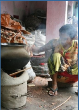
Another interesting pilot is Project Surya. In the next two years, Project Surya will replace traditional bio-fuel based cooking methods with inexpensive solar and other energy-efficient cookers in 6,000 homes in rural India. Scientists will place simple filter-based instruments in each household to record aggregate soot levels and document the cooker's ability to reduce indoor air pollution, one of the main environmental exposures particularly of women in developing countries. How do mobile phones fit in? They make it easy to collect high quality data from each cooker's filter in real-time. Participants capture and transmit images of the air filters to a centralized location for analysis to obtain soot readings and will prompt the users to replace the filters regularly to improve indoor air quality.
CENS also runs the PEIR Health Campaign that documents a person's exposure by using locations of polluting sources recorded by individuals in conjunction with models derived from data gathered and maintained by government agencies and other scientific organizations. PEIR, short for 'Personal Environmental Impact Report', uses GPS technology to determine the values indirectly. As you go about your routine -- jogging, commuting, running errands -- your mobile phone uses GPS and cell towers to record and upload your location every few seconds to your secure profile. Based on this location trace, the system infers your activity (walking, biking, driving, riding the bus) and logs it throughout the day. PEIR maps this combination of location, time, and activity to regional air quality and weather data to calculate your personal carbon footprint and your exposure to fine particles in the air.
Join us for Part 2 tomorrow for more examples of ways in which mobiles are used for a better and greener world.
Photo courtesy Project Surya and Dr. Nithya Ramanathan


Post new comment